Thornton, East Riding Of Yorkshire on:
[Wikipedia]
[Google]
[Amazon]
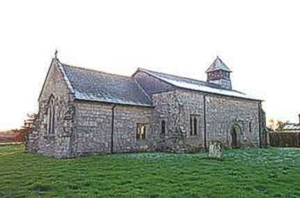
Thornton is a village and  The parish church of St Michael on Main Street is designated a Grade II*
civil parish
In England, a civil parish is a type of administrative parish used for local government. It is a territorial designation which is the lowest tier of local government below districts and counties, or their combined form, the unitary authority ...
in the East Riding of Yorkshire
The East Riding of Yorkshire, or simply East Riding or East Yorkshire, is a ceremonial county and unitary authority area in the Yorkshire and the Humber region of England. It borders North Yorkshire to the north and west, South Yorkshire to t ...
, England. It is situated approximately south-west of the town of Pocklington
Pocklington is a market town and civil parish situated at the foot of the Yorkshire Wolds in the East Riding of Yorkshire, England. The 2011 Census recorded its population as 8,337. It is east of York and northwest of Hull.
The town's sk ...
and north-west of the village of Holme-on-Spalding-Moor
Holme-on-Spalding-Moor (also known as Holme-upon-Spalding-Moor) is a large village and civil parish in the East Riding of Yorkshire, England. It is situated approximately north-east of Howden and south-west of Market Weighton. It lies on the ...
. It lies just to the north of the Pocklington Canal
The Pocklington Canal is a broad canal which runs for through nine locks from the Canal Head near Pocklington in the East Riding of Yorkshire, England, to the River Derwent which it joins near East Cottingwith. Most of it lies within a des ...
.
According to the 2011 UK census
A census of the population of the United Kingdom is taken every ten years. The 2011 census was held in all countries of the UK on 27 March 2011. It was the first UK census which could be completed online via the Internet. The Office for National ...
, Thornton parish had a population of 138, exactly the same as on the 2001 UK census
A nationwide census, known as Census 2001, was conducted in the United Kingdom on Sunday, 29 April 2001. This was the 20th UK census and recorded a resident population of 58,789,194.
The 2001 UK census was organised by the Office for National ...
.
The village was historically sometimes distinguished by the suffix "in Spalding Moor
Spalding Moor is a moor (in the sense of an area of low lying wetland) in the East Riding of Yorkshire in England. It lies between the River Derwent and the town of Market Weighton at the edge of the Yorkshire Wolds. It forms part of the Humbe ...
".
 The parish church of St Michael on Main Street is designated a Grade II*
 listed building
In the United Kingdom, a listed building or listed structure is one that has been placed on one of the four statutory lists maintained by Historic England in England, Historic Environment Scotland in Scotland, in Wales, and the Northern Irel ...
.
The other listed structures in the parish are Walbut Lock and Walbut Bridge on the Pocklington Canal, both of which are Grade II listed.
References
*External links
* Villages in the East Riding of Yorkshire Civil parishes in the East Riding of Yorkshire {{EastRiding-geo-stub